 |
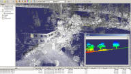
2011: Design and implementation of a rendering framework and
testbed for efficiently paging very large LIDAR datasets (hundreds
of GB), built on Qt and OSG. This example shows points colored by
laser intensity, and a gradient profile section. |
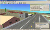 |
Design and implementation of the software
for the Virtual Terrain Project,
a set of Open Source libraries and applications which enable the rapid
construction of interactive 3D scenes from geospatial data for anywhere
on the planet. Fully internationalized UI supporting a user community
in 132 countries. Creation and maintenance of a corresponding website
acknowledged as the globally leading information source on the subject
of terrain visualization. |
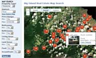 |
Implemented real estate
map search for Clark
Realty, with PHP/SQL on the server generating JavaScript on the client,
AJAX to the mapping API, and a C preprocessor to convert/reproject parcel
boundary GIS data from Shapefile to WKT for database storage.
Refined the UI based on client feedback. Notable for being the
only regional property search to display the polygon outline of every
property in a slippy map. |
